xrspatial.zonal.crop#
- xrspatial.zonal.crop(zones: xarray.core.dataarray.DataArray, values: xarray.core.dataarray.DataArray, zones_ids: Union[list, tuple], name: str = 'crop')[source]#
Crop scans from edges and eliminates rows / cols until one of the input values is found.
- Parameters
zones (xr.DataArray) – Input zone raster.
values (xr.DataArray) – Input values raster.
zones_ids (list or tuple) – List of zone ids to crop raster.
name (str, default='crop') – Output xr.DataArray.name property.
- Returns
crop_agg
- Return type
xarray.DataArray
Notes
This operation will change the output size of the raster.
Examples
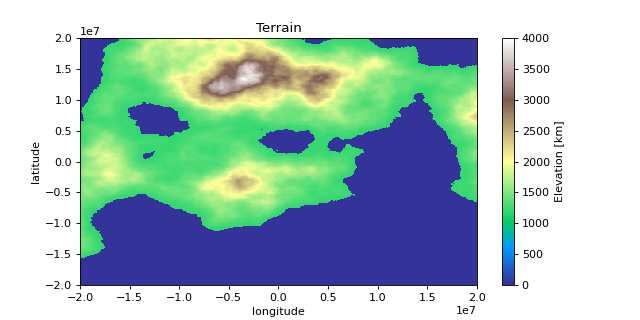
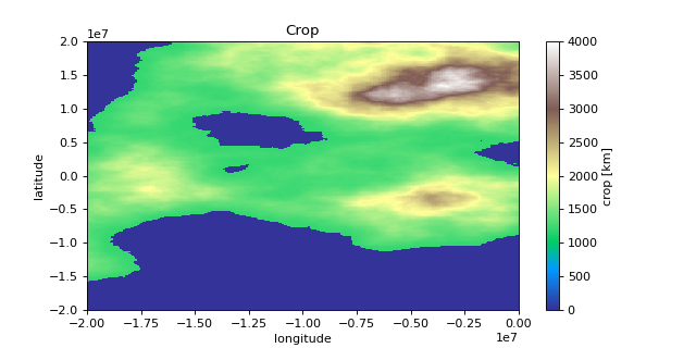
import matplotlib.pyplot as plt
import numpy as np
import xarray as xr

from xrspatial import generate_terrain
from xrspatial.zonal import crop

# Generate Example Terrain
W = 500
H = 300

template_terrain = xr.DataArray(np.zeros((H, W)))
x_range=(-20e6, 20e6)
y_range=(-20e6, 20e6)

terrain_agg = generate_terrain(
    template_terrain, x_range=x_range, y_range=y_range
)

# Edit Attributes
terrain_agg = terrain_agg.assign_attrs(
    {
        'Description': 'Example Terrain',
        'units': 'km',
        'Max Elevation': '4000',
    }
)

terrain_agg = terrain_agg.rename({'x': 'lon', 'y': 'lat'})
terrain_agg = terrain_agg.rename('Elevation')

# Crop Image
values_agg = terrain_agg[0:300, 0:250]
cropped_agg = crop(
    zones=terrain_agg,
    values=values_agg,
    zones_ids=[0],
)

# Edit Attributes
cropped_agg = cropped_agg.assign_attrs({'Description': 'Example Crop'})

# Plot Terrain
terrain_agg.plot(cmap = 'terrain', aspect = 2, size = 4)
plt.title("Terrain")
plt.ylabel("latitude")
plt.xlabel("longitude")

# Plot Cropped Terrain
cropped_agg.plot(cmap = 'terrain', aspect = 2, size = 4)
plt.title("Crop")
plt.ylabel("latitude")
plt.xlabel("longitude")


>>> print(terrain_agg.shape)
(300, 500)

>>> print(terrain_agg.attrs)
{
    'res': (80000.0, 133333.3333333333),
    'Description': 'Example Terrain',
    'units': 'km',
    'Max Elevation': '4000',
}

>>> print(cropped_agg.shape)
(300, 250)

>>> print(cropped_agg.attrs)
{
    'res': (80000.0, 133333.3333333333),
    'Description': 'Example Crop',
    'units': 'km',
    'Max Elevation': '4000',
}